 Milford Sound Boat Tour
Mitre Peak: Milford Sound's Five-Summit Spike
Mitre Peak is the mountain that ends up in almost every Milford Sound photo, and this page explains why. DOC puts the rock walls at 1,692 metres rising straight from the water, the summit is actually five peaks in a tight group, and the Māori name is Rahotu. Below you will find the numbers behind the silhouette, the story of the name and the first climb, and every practical way to see it, from a 30-minute foreshore stroll to a boat tour on the fiord. If you are deciding between cruises, the Milford Sound boat tour comparison lists the bookable options side by side.
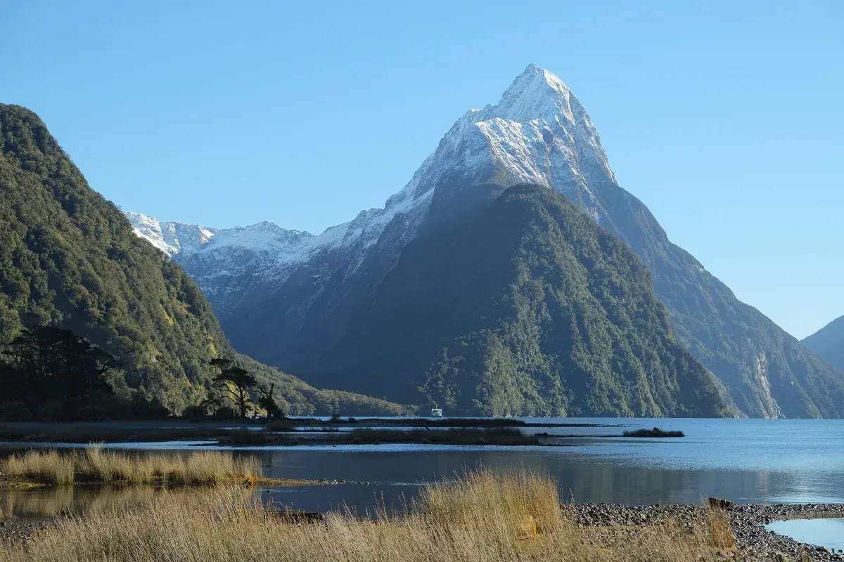
Snow-covered Mitre Peak on a clear winter's day, seen from the Milford Sound foreshore. Photo: Pseudopanax at English Wikipedia, Public domain, via Wikimedia Commons
Quick answer Mitre Peak at a glance
Mitre Peak rises 1,692 metres above Milford Sound according to DOC, though the Wikipedia climbing article gives 1,683 m. It is a closely grouped set of five peaks that reads as a single point from most viewpoints, and it drops almost sheer into the fiord. The Māori name is Rahotu. Captain John Lort Stokes named it for its likeness to a bishop's mitre.
Key takeaways
- One direct way to see it from the water is the Mitre Peak Small Boat Cruise, a 2-hour cruise from $100 per person.
- On foot, the Milford Foreshore Walk takes about 30 minutes and starts at the main car park.
- For a flight over Fiordland as well, the Fly-Cruise-Fly from Queenstown pairs a 2-hour cruise with flights in both directions.
- Rain changes the whole scene, and the Milford Sound weather guide explains what to expect.
Mitre Peak in Figures
The key numbers for Mitre Peak, drawn from DOC and Wikipedia sources, including one height figure that official pages disagree on.
The Numbers
Mitre Peak's height is quoted two ways. DOC says the sheer rock walls rise 1,692 metres directly from the water, and the Wikipedia Milford Sound article uses the same figure. The Wikipedia Mitre Peak article gives the elevation as 1,683 m (5,522 ft) with a topographic prominence of just 95 m. For trip planning the two numbers make no practical difference. What matters is that the rock drops almost sheer to the fiord, which is why the silhouette looks so sharp from the water.
The fiord itself frames the peak. Milford Sound runs 15 kilometres inland from the Tasman Sea, and is up to 1.94 km wide. The rock faces on both sides rise 1,200 metres or more.
| What | Figure | Source |
|---|---|---|
| Mitre Peak height (walls from the water) | 1,692 m | DOC |
| Mitre Peak elevation (climbing figure) | 1,683 m (5,522 ft), prominence 95 m | Wikipedia Mitre Peak |
| Fiord rock faces on either side | 1,200 m or more | Wikipedia Milford Sound |
| Fiord length | 15 km inland from the Tasman Sea | Wikipedia Milford Sound |
| Fiord width | Up to 1.94 km | Wikipedia Milford Sound |
| First ascent | 13 March 1911, Jim Dennistoun | Wikipedia Mitre Peak |
The Names and the Five Peaks
Mitre Peak is not one summit. It is a closely grouped set of five peaks that looks like a single point from the usual viewpoints, which is part of the trick of the place. Captain John Lort Stokes of HMS Acheron gave it the English name for its likeness to a bishop's mitre, the tall pointed hat. The Māori name is Rahotu.
Nobody is sure how long people have looked at it. Māori visited Milford Sound over 1,000 years ago, and Captain John Grono made the first European sighting of the fiord around 1812, naming it after Milford Haven in Wales.
Climbing history is short and steep. Jim Dennistoun made the first ascent alone on 13 March 1911, reaching the summit at 13:15 via the southeast ridge from Sinbad Gully while Joe Beaglehole went part of the way. The second ascent in 1914 by Jack Murrell and Edger Williams found Dennistoun's handkerchief still in a cairn, and the third came in 1941 through J.H. Christie and G. Raymond. There are six established climbing routes, ascents stay infrequent, and most climbers reach Sinbad Bay by boat.
Geologically the summit is steep granite slabs. The whole fiord is a glacial valley, not a true sound, which is a river valley flooded by the sea. Glaciers carved these walls out thousands of years ago, and the deep water is what lets a 1,692-metre wall sit beside a boat.
Sources: DOC, Wikipedia Mitre Peak), Wikipedia Milford Sound
Where to See Mitre Peak
Four ways to see the peak, from free walks on the shore to flights over the top.
From the Foreshore and the Lookout
The free walks start at the car park. The Milford Foreshore Walk starts at the entrance of the main visitor car park and is an easy stroll along the shoreline of about 30 minutes, with the peak straight across the water. The Milford Sound Lookout Track takes 10 minutes from the car park behind the cafe, with a number of steps up to a lookout over the sound. fiordland.org.nz lists the same pair as a 30-minute Piopiotahi Milford Foreshore Walk and a 10-minute Milford Lookout Walk.
Practical timing matters here. Allow 45 minutes to park and reach the cruise terminal, and check in 20 minutes before any boat departure if you have one booked. Parking costs NZD$10 per hour before 3pm and NZD$5 per hour after, per milfordlodge.com, while Southern Discoveries lists the main car park at $20 for five hours. Deepwater Basin has limited free parking and a free shuttle bus every 15 to 20 minutes, about 2 km to the marina.
From the Water
The boat is the closest view, because the wall rises straight out of the fiord. The Mitre Peak Small Boat Cruise is a 2-hour cruise at $100 per person run by the smallest cruise operator in the fiord, and its route passes Sinbad Gully, Mount Pembroke and Mitre Peak itself before sailing out into the Tasman Sea. Meeting point is the Milford Sound Visitor Terminal. The Glass-Roof Catamaran Cruise runs 105 minutes at $93 per person and covers the length of the fiord to the Tasman Sea entrance.
If you are coming from Queenstown rather than staying at the fiord, the Coach and Cruise from Queenstown costs $148 per person for a 12-hour day with photo stops on the Milford Road. Each cruise page lists its own route. Note that Mitre Peak Cruises, the company behind Mitre Peak Small Boat Cruise, has its own review page at Mitre Peak small boat cruise, which covers the operator in detail.
From the Air
Fly-cruise trips add a flight over the mountains, which no walk can match. The Fly-Cruise-Fly from Queenstown costs $467 per person for a 5-hour day with guaranteed window seats and a 2-hour cruise on the fiord. The Flight and Cruise from Queenstown runs 4.5 hours at $512.29 per person with a 1 hour 45 minute cruise. The Flight and Cruise Day Trip costs $485.96 per person, carries up to 30 people and flies through the fiord to land.
The full spread of fly options is on the homepage fly-cruise section. Snow is part of the winter picture too. RealNZ says snow settles on Mitre Peak from June onward, which changes the photo entirely.
Sources: DOC walking brochure, fiordland.org.nz
The Rest of the View
Mitre Peak shares the frame with named peaks, two permanent waterfalls and a gully that climbers use as a doorway.
The Other Peaks
The Elephant rises 1,517 metres and The Lion rises 1,302 metres, and both frame the fiord. Between them and Mitre Peak, the walls run 1,200 metres or more on either side of a channel up to 1.94 km wide, so the boat sits in a corridor of rock. Mount Pembroke appears on the Mitre Peak Cruises route along with Sinbad Gully, the gully that gave Jim Dennistoun his 1911 line up the southeast ridge.
The Falls
Two permanent waterfalls discharge into the fiord. Lady Bowen Falls is about 160 metres high and the tallest permanent one, fed by the 9 km Bowen River, which also supplies electricity and drinking water for the Milford Sound locality. The Māori name is Hineteawa, and the falls were named for Diamantina Bowen after Governor George Bowen visited aboard HMS Clio in 1871. A short on-demand boat service to the falls runs a half-hour round trip from the wharf.
Stirling Falls is the second-highest permanent fall at 151 metres by Wikipedia's figure, though Southern Discoveries lists it at 155 m, and it has existed for 15,000 years. Rain multiplies everything. When it rains, hundreds of temporary cascades form along the mountainsides, some falling a thousand metres, fed by rain-soaked moss and lasting a few days. Semi-permanent falls such as Fairy Falls and Palisade Falls can last up to two weeks without rain. The rain and wildlife section covers what that means for a cruise, and rainfall can reach 250 mm in 24 hours.
Sinbad Gully and the Shore
Sinbad Gully sits at the base of Mitre Peak and matters twice. It was the approach for the first ascent in 1911, and it is a named stop on the Mitre Peak Cruises route today. Most climbers still come by boat to Sinbad Bay.
Along the shore, Seal Rock is where New Zealand fur seals sunbathe and rest between fishing trips, and Harrison Cove was the first place settlers anchored in the sound. The 2-hour cruise at the $100 mark names Sinbad Gully, Seal Rock and Mitre Peak on its route, which makes the boat an efficient way to take in the whole wall of peaks.
Sources: Wikipedia Milford Sound, Wikipedia Lady Bowen Falls, Southern Discoveries
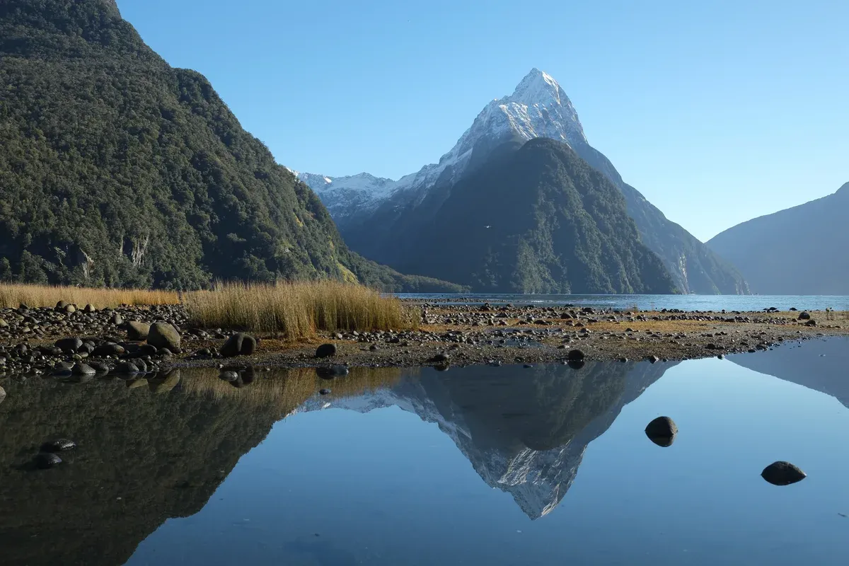
Mitre Peak with snow at the top, reflected in the water on a calm clear winter's day. Photo: Pseudopanax at English Wikipedia, CC BY 4.0, via Wikimedia Commons
Tips for Seeing Mitre Peak
Practical points, each one grounded in a sourced figure or rule.
Do
- Do the 10-minute Milford Sound Lookout Track if time is short, because it starts behind the cafe and climbs a number of steps to a lookout over the whole sound.
- Do allow 45 minutes to park and reach the cruise terminal, and check in 20 minutes before departure, because the fiordland.org.nz fact sheet gives those figures.
- Do bring your own food on the $100 small boat cruise, because no food is sold on board and lunch is not included.
- Do consider a winter visit for snow on the summit, because RealNZ says snow settles on Mitre Peak from June onward and winter is the quietest season.
- Do check the Milford Sound weather before you go, because rain can reach 250 mm in 24 hours and changes both the road and the view.
Don't
- Don't drive the Milford Road without checking conditions between June and October, because avalanche control closures run through winter and spring on SH94.
- Don't plan on reaching the peak's base from the shore, because the rock drops almost sheer into the fiord.
- Don't try to climb it casually, because there are only six established routes, ascents are infrequent and most climbers need a boat to Sinbad Bay just to reach the start.
- Don't expect to park for free at the main terminal, because parking costs NZD$10 per hour before 3pm and NZD$5 after, though the foreshore walk connects free parking 20 minutes away.
Mitre Peak Questions
How tall is Mitre Peak?
DOC gives 1,692 metres of sheer rock rising directly from the water. The Wikipedia climbing article gives the elevation as 1,683 m (5,522 ft) with a 95 m prominence. Both figures describe the same mountain from different baselines.
Why is it called Mitre Peak?
Captain John Lort Stokes of HMS Acheron named it for its likeness to a bishop's mitre. The Māori name is Rahotu. See the names section on this Mitre Peak guide for the full story.
Is Mitre Peak one mountain or several?
It is a closely grouped set of five peaks that looks like one point from the usual viewpoints. The Mitre Peak Small Boat Cruise passes Mitre Peak on a 2-hour route.
Can you climb Mitre Peak?
Yes, but it is a serious climb. Jim Dennistoun made the first ascent alone on 13 March 1911 via the southeast ridge from Sinbad Gully, and there are six established routes today. Most climbers reach the start by boat to Sinbad Bay.
Where is the best view of Mitre Peak without a boat?
The Milford Sound Lookout Track takes 10 minutes from the car park behind the cafe, and the Milford Foreshore Walk is an easy 30-minute stroll along the shoreline from the main car park entrance. Both are covered in the Milford Sound boat tour guide to the fiord.
Does snow settle on Mitre Peak?
Yes. RealNZ says snow settles on Mitre Peak from June onward, and winter brings crisp skies with the quietest crowds of the year. Winter road conditions are the trade-off, as the weather guide explains.